Bicycle Route between Seoul and Busan
Go back to the Bicycling in Korea website
Summary of available documents
|
Introduction
Welcome to the renewed pages about the bicycle route between Seoul and Busan. The route has been revised and a complete new set of maps is available since July 2012.
The route has undergone a major change. Only the section between Mungyeong (in the center of the country) and Yangsan (near Busan) remains the same as it has been for many years, apart from some corrections. But between Paldang Bridge near Seoul and Mungyeong  the course has been partly re-routed over the "sa-daegang" (4 big rivers) biketrails. These biketrails were recently opened and the construction was part of a huge civil engineering project to control the flow and to remodel the banks of the four biggest rivers in Korea. To connect the various river bike trails, special bike routes were set out that follow mainly existing roads. This way, a route was established connecting Seoul with Busan. This "sa-daegang" route coincides for some parts with my original route, but obviously not for stretches where a brand new bike path was constructed along a river. Now, the share of "sa-daegang" trails in my route is 35%.
Even now the government has taken over the guidance of cyclists between Seoul and Busan, a task that I have done and still do with much pleasure, it is not a reason to stop supplying maps and info like I have been doing since 2005. On the contrary, I think it is desirable to maintain my Seoul-Busan bike route as an alternative to the "sa-daegang" route. The reason for this is that in my opinion the government's route has major drawbacks. I have summarized the pros and cons and I invite anyone who has been on a "sa-daegang" trail to object or add or comment on it. It must be noted also that all information along the trails as well as leaflets and brochures about the trails, as well as the official website is in Korean only. The information that I provide to the cyclist is limited to navigation only, for touristic, cultural and historic sites please refer to books and other sources.
the Maps
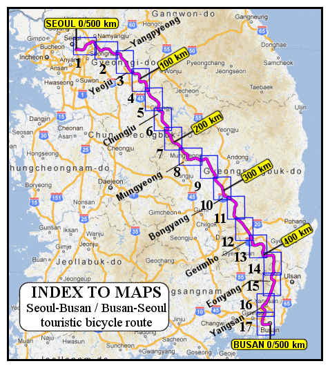
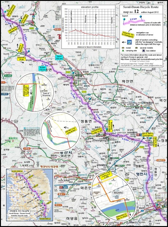
There is a set of 17 digital maps, see index below, showing a scenic route for cyclists to take on a journey from Busan to Seoul or the other way around. Cues for navigating at junctions are written in yellow frames on the maps. See the sample (part of map #8), also below you find a downscaled example of one complete map (#12). The cues are for both directions and supply additional directions where the map only might not offer sufficient info. On the sections that coincide with the "sa-daegang" trails, the cues are omitted, because there are many signs and marks along the trail to guide you. The maps are not directly available for downloading, but they can be obtained by contacting me by email (see bottom of this page). Make a hard copy of the digital file on A4 size paper or larger, portrait orientation. The maps are free of charge and in return I am glad to receive any information that may improve the route itself or the cues on the maps. The basic map data is taken from a scale 1:75,000 road map atlas. Original texts on the maps are in hangeul, the Korean script. All texts that I added are in English, including the names of major towns along the routes. At every full 50 kilometers from Seoul and from Busan, a "milestone" is placed on the map in a blue frame. On each map there is a vertical profile (elevation in meters versus distance to Seoul) of the route section corresponding with the map.the Route
The route starts (ends) at the south end of Banpo Bridge, the most bicycle friendly bridge across the Han River in Seoul, 7 km south of the center of the city. It ends (starts) at Seomyeon Junction, Busan's most important hub of commercial- and other activity. From Seomyeon, it is 7 km to the old center (Nampodong) and 12 km to Haeundae Beach. The total distance is almost exactly 500 kilometres. The main objective has been to select roads that are relatively quiet, leading through peaceful countryside with scenic beauty. Difficult mountain passes and other steep sections are avoided, all roads are paved and exclusive bike paths are included wherever possible or desirable. There are no tunnels on the route that are shared with motorized traffic. Some cities are on the route, even cities can be a welcome change after many hours of riding through quiet rural landscapes. These cities are Yangpyeong, Yeoju, Chungju and the route passes at close distance from Jeomchon (a.k.a. Mungyeong) and Yeongcheon. A number of small towns are encountered, where basic needs can be found, including convenient places for a pleasant stop and accommodation for the night.GPS and Google Maps
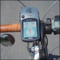 The route has been documented in tracks files in .gpx format, the general data format for GPS receivers. The tracks are split up in sections of approximately 50 kms, to accommodate GPS receivers that are limited in the number of track points per file. There are two routes available, one is Seoul to Busan and the other is Busan to Seoul (the one is not just the inverse of the other!). If you want to receive the files (for either direction there is one file), contact me and I'll send it to you. You need your own software to load the file into the GPS unit. Projection system: WGS84 datum. For background maps, Garmin Korea has published the "Korea City Navigator English Version". The use of background maps is not strictly necessary when using the tracks files.
For users of smart phones or other devices that can display Google's online map data in conjunction with a GPS position, the complete track in Google Maps (only one track for both directions) is available on the internet, split up in the north part and the south part. Of course anybody can use these links to study the track in detail in Google Maps on a convenient desk computer. The tracks are all derived from originally recorded tracks by myself.
Go back to the Bicycling in Korea website
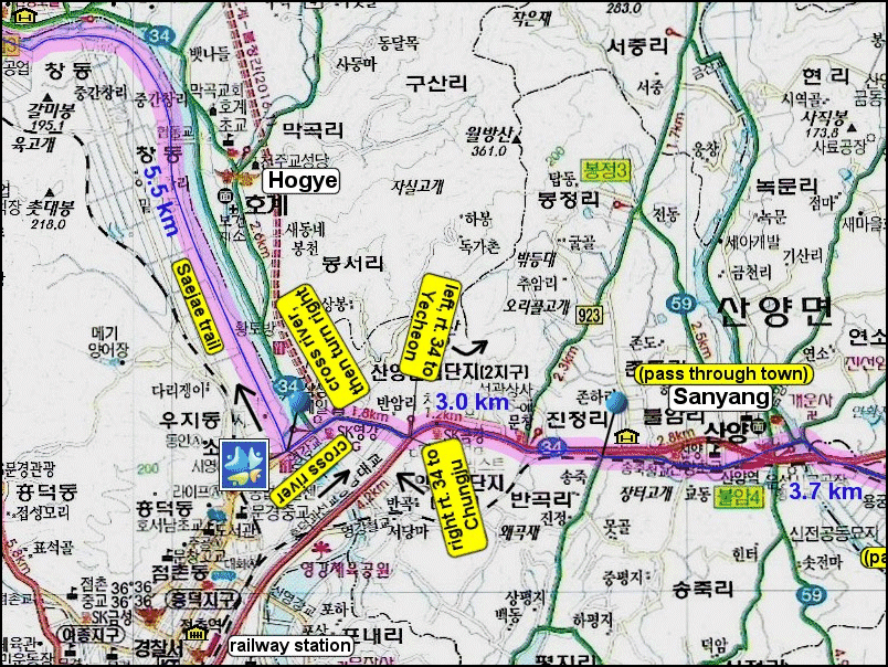
example of a part of a map (map #8)
example of a complete map
map #12, downscaled to 1/3 of original size

 Back to the page you came from


